
Proposal for a Geographic Information Systems (GIS) based analysis of socialvulnerability to air quality: application in Vitoria-Gasteiz
DOI:
https://doi.org/10.6036/10943Keywords:
urban planning, social vulnerability, social vulnerability, air quality, GIS, modelling, air pollution, pollution, pollution policies, vulnerable populationAbstract
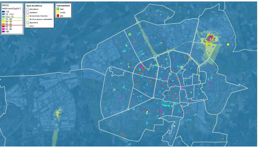
Despite the fact that air pollution is one of the main environmental concerns in Europe, causing more than 400,000 premature deaths each year, and affecting certain groups in particular, there are no known specific analyses of the social vulnerability of this pollutant that would allow us to guide policies to improve air quality in the different municipalities. For this reason, a first approximation of an analysis of social vulnerability to air quality has been developed to guide municipal policies in this area. The proposal proposes a zonal analysis of exposure in GIS in which the modelled information on air pollution is cross-referenced with the location of buildings housing the main vulnerable groups. The buildings have been classified according to the type of vulnerable population using them and their degree of vulnerability. The results indicate that this proposal allows a visual and simple identification of the levels of air pollution to which each sensitive building is exposed, facilitating the possible identification of those with levels higher than the current legislation or the recommendations of the WHO. Based on the exposure on the façade of the buildings, the proposal presented allows four levels of severity with respect to air pollution to be established, establishing the first steps of a prioritisation of improvement needs. This first prioritisation can be adjusted according to the type of population housed in each sensitive building and the vulnerability of the groups it houses. The proposed GIS-based social vulnerability analysis is particularly interesting when available resources are scarce, but it must be complemented by detailed analyses of the social vulnerability of the prioritised sensitive buildings before the implementation of improvement actions.
Downloads
Published
Issue
Section
License
Copyright (c) 2024 DYNA

This work is licensed under a Creative Commons Attribution-ShareAlike 4.0 International License.

